‘Weather War’
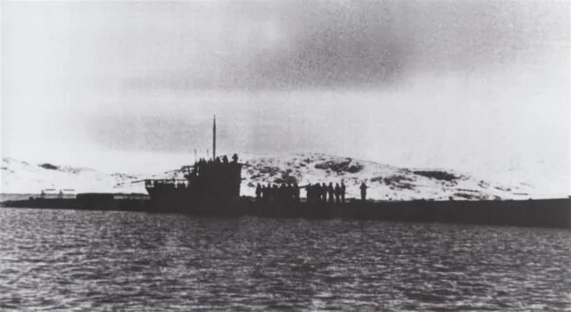
U-boat 537, 23 October 1943 off the coast of Labrador. Source unknown.

U-537, just off the coast of Hutton Penninsula, Labrador. Crewmen can be seen on deck loading Kurt into rubber dingies to be brought ashore. Taken 22 October 1943, by an unknown crewman. (Photo credit of Wikimedia Commons)
THE WEATHER WAR
Wetter-Funkgerät Land-26 AKA Weather Station Kurt
On October 22nd, 1943, a Nazi U-boat surfaced within sight of the coast of Labrador. U-537, a type IXC U-boat, was commanded by Kapitänleutnant Peter Schrewe and carried three pieces of precious cargo: 2 German meteorologists and a piece of equipment named Wetter-Funkgerät Land-26. Translated as Land Weather Station, this equipment would be vital to gaining the upper hand in the North Atlantic Weather War and the larger information war between the Allied and Axis powers of the Second World War. Because of the Earth’s counter-clockwise rotation, weather systems mostly move from West to East.
This put the Nazis at a significant disadvantage as the Allies had Canada and the United States to keep tabs on the weather heading towards Europe in a few days. But the Nazis had no such luck and they had no inkling of the systems headed their way. This lack of information meant the Nazis had to play according to Mother Nature, unable to predict what may be coming their way.
This affected bombing raids, reconnaissance missions, and U-boat manoeuvres among others. Add to this the volatile and wildly unpredictable climate of the North Atlantic and Britain’s expertise in maritime meteorology, the Nazis knew they had to get North Atlantic weather data from the far side of the Pond, the problem was how.
Built by Siemens corporation, Wetter-Funkgerät Land-26 was nicknamed ‘Kurt’ for one of the meteorologists accompanying the station on U-537. The entire station was made up of 10 one-meter-high drums. One of the drums contained all of the meteorological instruments (thermometers for air and sea surface temperatures, a barometer to measure atmospheric pressure, and an anemometer to measure wind speed and direction), a weather vane, and a 33-foot antenna sprouting from the top. The other 9 drums contained nickel-cadmium batteries, each weighing 220 lbs. These batteries would allow a two-minute broadcast via a 150W Lorenz FK-type transmitter every 3 hours for 6 months. At least, that was the plan, but we’ll get to that.
U-537 surfaced in Martin Bay, Labrador and dropped anchor. The land surrounding Martin Bay is some of the Northernmost in Labrador and part of Canada’s Tundra biome.The area was chosen by the Kriegsmarine (German Navy) because they believed it to be remote enough to go unnoticed by North American Allied forces who were patrolling the East Coast.
Ever diligent in their planning, the Kriegsmarine considered local Inuit when planning where to station ‘Kurt’, believing the scouted area was far enough away not to be discovered by hunters. After a scouting party found a spot ¼ of a mile inland, ten sailors and the two scientists, along with ‘Kurt’, boarded rubber dinghies and rowed ashore. This meant the crew that went to shore had to set ‘Kurt’ up in near-total darkness, in the unforgiving Canadian Tundra. The whole operation took 28 hours to complete, and, following a transmission test, U-537 went on to complete her anti-shipping patrol off of Newfoundland, before heading back to Europe.

Image of the full weather station after being set up, 22 October 1943, taken by a crewman before leaving. (Photo credit of Wikimedia Commons)
U-537 was torpedoed and sunk with all hands on board in November of 1944. Although Labrador, along with Newfoundland, wouldn’t become a Canadian province for another 6 years, the site was chosen for its isolation as much as its location. To further camouflage the station, the station had ‘Canadian Meteor Service’ painted across it, a misspelling of ‘Canadian Meteorological Service’, an agency that, by such a name, has never existed.
Additionally, the landing crew scattered American cigarette packages around the site so that, should any allies chance upon the site, they might be moved to ignore it assuming it’s something secret.
U-537 left Labrador on October 23rd, 1943. Only a month later, Kurt was being jammed by an unknown source and by New Year of 1944, Kurt had gone silent. Why Kurt stopped transmitting is a mystery. Speculation is rampant and theories abound. First, there are the jammed signals. According to known records, the Allies (Canadian, American, or otherwise) did not have any knowledge of the weather station. That being said, as a museum that deals in secrecy, we know that just because you do not have the evidence doesn't mean it didn’t happen. Second, when the site was eventually recovered and recorded by the Canadian War Museum, Kurt was found to have several cut wires. Someone had been there, but they didn’t leave any more evidence than that. Third, although the Germans had considered the North Atlantic Canadian weather when designing the station, theory is not a replacement for reality. Kurt was dropped off at the end of October, the beginning of the worst weather for Atlantic Canada. Saltwater is extremely corrosive, and North Atlantic winds make sure to cover anything near the coast in it. Fourth, the batteries may have been depleted faster than intended. Batteries can have a harder time holding onto their charge in colder temperatures, meaning Kurt just couldn't last as long as intended.
In 1944, a second station was planned to be erected in North America, but U-867 was sunk on its journey, leaving Kurt as a lone watchman in Martin Bay.

Dr. Alec Douglas and his team in 1981 as they document Kurt and its site. The weather station went to the Canadian War Museum (Ottawa) from Labrador, where it remains today. (Photo credit of the Canadian War Museum)
Discovery
For nearly 40 years, Kurt watched the passing of the seasons from its station on a 170-foot high hill. Over time, its black and white camouflage rusted, and, though largely undisturbed, someone had opened the canisters and made a small mess of the site. Nonetheless, there is no record of Allied forces discovering or disabling Kurt. Three separate groups of people found Kurt in 1977. The first two were surveying the Labrador coast: Historian Selma Barkham and Geomorphologist Peter Johnson. Barkham was investigating the presence of Basque whaling ships in the Age of Discovery, supported by Canadian Geographic, when she stumbled upon the Weather Station.
The second, Peter Johnson was surveying Labrador for the Torngat Archaeological Project, supported by the Smithsonian Institute and Bryn Mawr College (the Alma Mater of Dr. Elizabeth Laird, a pioneer in biomedical physics and a contributor to the development of Canadian Radar). Johnson assumed the station was a Canadian installation and gave it the name ‘Martin Bay 7’.
The third group to discover Kurt in ’77 was a pair of Inuit brothers-in-law from Killiniq Island, just north of Martin Bay (Taliarusik Inlet in Inuktitut). Michael Keelan and Paul Jararuse were char fishing on the shore before wandering inland ahead of going home. The island was well-known as a good fishing spot among local Inuit. Keelan recalled seeing strange writing on the canisters, papers, and batteries strewn about the site. They asked around Killiniq about the strange canisters, and were told by elders “There was some kind of a weather station there that wasn’t American.” A rifle cartridge with the inscription ‘British Dominion’ was found underneath one of the canisters, which Keelan said most hunters used in their British Enfield rifles. Only a year later, the Northwest Territories Government removed any Inuit living on Killiniq Island and relocated them elsewhere.
Finally, the fourth encounter Kurt had was not in person but through the archives. An amateur German Historian, Franz Selinger, was looking to write a history of the German weather service and scoured through German archives to do so. His search eventually led to U-537’s logbook, where Kurt’s journey had been systematically recorded. Selinger made contact with Dr. Alec Douglas (W.A.B. Douglas), a historian for the Canadian Armed Forces, to let him know of his discovery. Kurt was officially documented in 1981 by Douglas. By 1981, Kurt was in rough shape, having endured nearly 40 years of Northern Labrador’s weather and seawater, which had left the station rusted almost beyond recognition. The full station is now fully restored and on display in the Canadian War Museum in Ottawa. Weather Station Kurt remains the only known enemy military installation on North American soil in the Second World War.
The Importance of Weather Forecasting.
Many of us today take our daily weather forecast for granted. We open an app, turn on the TV or the radio, and we expect the forecast to be reliable. Weather can have a huge impact on an event (an outdoor wedding for example) and most do not realize the reliance we have on accurate weather forecasting.
Radar was an integral part of the Allies winning the weather war. Some groups began tuning their radars to watch the weather (Project Stormy Weather, later based at McGill and called Stormy Weather Project), while other groups used radar to ‘see through’ clouds during nighttime blind bombing. Before Radar was in wider use, nighttime bombing raids were regularly cancelled because of cloudy weather and poor visibility. D-Day itself was pushed back a day because the English channel was too rough for the crossing on 5 June. D-Day only took place on June 6th, 1944 because of poor conditions.
By the time Kurt was in operation, the war in the Atlantic had shifted dramatically in the Allies' favour. In 1943, the Americans began rolling out the Consolidated B-24 Long Range Liberator, which could reach U-boats in the mid-Atlantic. Until this point, the Allies didn’t have a plane with the range to get to the Mid-Atlantic. Knowing this, the U-boats would hang out there waiting for Allied Convoys to torpedo. The Long-Range Liberator made this impossible. Based out of Northern Scotland and Iceland, the B-24 was equipped with an ASV (Airborne to Surface Vessel) Radar and would fly out at night. U-boats had to surface every 24-48 hours to recharge the batteries and replenish fresh air. They usually surfaced at night when it was safest and crew members could safely be on deck.
The B-24 ended the serenity of a Mid-Atlantic night with a Leigh Light of 22 million candle power and depth charges. The B-24 and her crew would fly out of Coastal Command in Iceland or Scotland, scanning with her radar for a U-boat. The centimeter wavelengths allowed the radar to pick a U-boat schnorkel out of the thousands of waves surrounding it, each reflecting a radar echo. This is incredibly impressive considering, not 4 years earlier, the British were working with 1.5-meter wavelengths, before that it was 12-meter wavelength. Centimeter wavelengths allowed for the B-24 to be incredibly effective against U-boats. The Carbon Arc Leigh Light only lasted a few seconds but was enough to blind any sailors on deck before deploying depth charges at the perfect time. The position of the U-boat was then sent to the nearest Allied naval convoy, which would send a boat to the last known coordinates to make sure she didn’t resurface. The Leigh Light was so effective that U-boats were ordered to recharge their batteries during the day so that they could see the plane coming. After some time, the Kriegsmarine ordered U-boats to stand and fight using the deck gun on the bow (by ’44, an anti-aircraft gun was installed in the tower). Wearing welding goggles, a gunner would listen for the Liberator and watch for the Leigh Light. Through welding goggles, the Leigh Light did not have the same effect. The gunner would use the Leigh Light as a target and try to shoot the Liberator down. The Nazis were able to detect the ASV Radar by ’43 (using FuG 350 Naxos) but it was too little too late: the RAF finally had the upper hand against the Kriegsmarine. In 1944, U-867 was carrying the second weather station destined for North America but was sunk by an RAF B-24 Long Range Liberator off the coast of Bergen, Norway not 20 days into her deployment. All 60 hands were lost.
The story of Weather Station Kurt is not radar, but it highlights the importance of information in warfare: the more information you have, the better and further ahead you can plan. The importance of weather data and forecasting cannot be overstated and, for the Nazis, that meant placing an autonomous weather station on the northern tip of Labrador and hoping that no one would find it.
The creation of this page was funded by the Ontario Senior’s Community Grant. Our thanks to the provincial government for funding this program.